GeoSuite AllWorks
Ultimate solution for seismic interpretation
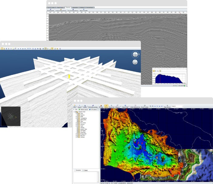
GeoSuite AllWorks is a GIS-based solution for processing, interpretation and 3D Visualization of Ultra High-Resolution post-stack, single channel and sub-bottom profiler data.
It also can be used for the integration with results from other sensors, such as side scan sonar, magnetometer and single/multibeam bathymetry.
Powerful data driven

Handle seismic profiles, wells, GeoTIFFs, isopack maps, bathymetry, tide tables, shapefiles, etc.

Advanced batch processing and import/ export tools are available for each resource defined in a project.
Automatic georeferentiation
The pulsing heart of GeoSuite AllWorks resides in its powerful GIS engine.
Handle any kind of georeferenced data within the same project even if they have different projections: import, display and analyze data all together on the same map view, in a click.
GeoSuite Allworks provides automatic processing of navigation data: no spikes, no missing coordinates.
GeoSuite AllWorks can always recover positioning information, even when data is partially missing or affected by noise.
Processing and interpretation tools
Seismic interpretation is now effortless and pleasurable thanks to GeoSuite AllWorks.
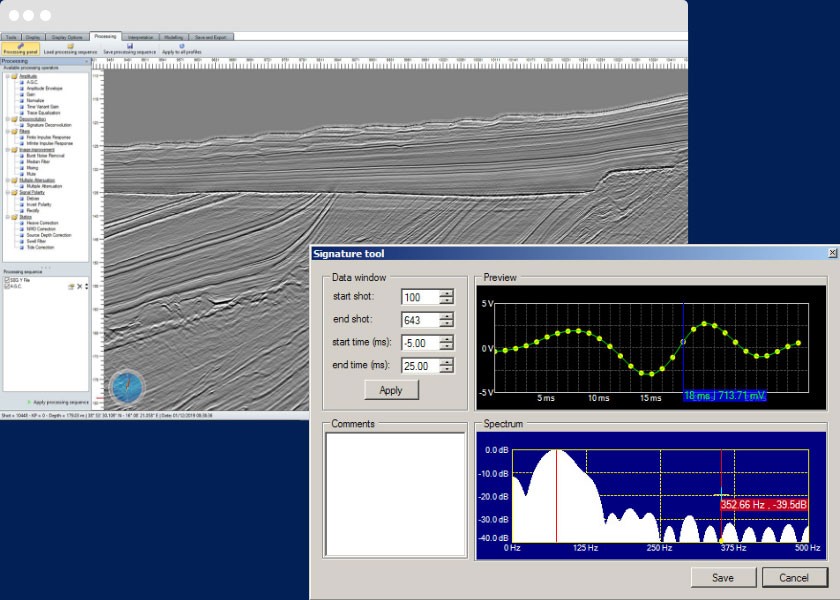
GeoSuite AllWorks features a wide set of processing operators including AGC, TVG, Amplitude Envelope, Signature Deconvolution, FIR, IIR filters, Multiple Attenuation and many others.
Comprehensive set of tools allow to perform accurate static corrections on single channel data: swell filter, tide corrections, source depth correction and NMO.
Our wide set of interpretation tools features a sophisticated autopicking operator and an automatic seabed finder tool.
Multiple operations and QC tools can be performed on each seismic event: horizon surface 3D interpolation, fault-horizon linking, well calibration over seismic profile, seabed positioning check against bathymetric data and velocity analysis visualization.
Advanced reporting
tools
GeoSuite AllWorks features a wide set of
tools to produce high quality output for
reports.
High resolution image export and advanced interpretation data export tools, allowing interoperability with third-party software.

GeoSuite AllWorks supports standard file formats for seismic data like SEG-Y and XTF. Moreover GeoSuite AllWorks features an automatic import procedure that can detect and overcome any issue derived from the usage of non fully compliant SEG-Y files.

The main concern in our software design process is ease of use. Therefore, we focused our attention on designing the most simple, user-friendly and flexible user interface possible for GeoSuite AllWorks. No clumsy windows, no crowded toolbars: every button is exactly where you expect it to be.